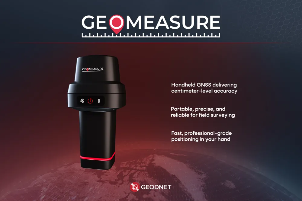
GEO-MEASURE by GEODNET is a portable RTK GNSS receiver that provides cm-level accuracy, revolutionizing the use of precise positioning data in various fields such as surveying, drones, and autonomous driving.
HonoreeMobile Devices무선 통신효율성 증대사용자 경험지속 가능한 기술AI연결성
GEO-MEASURE
0
0
GEODNET
One-Line Product Definition
Problem Definition
Accurate location data with centimeter-level precision is essential in fields such as construction and surveying. However, traditionally, this required expensive surveying equipment or base station setups. General handheld GPS devices, which have errors of several meters, were unsuitable for precise mapping. Despite the demand for small-scale land surveying and DIY landscaping, the price of professional equipment (tens of thousands of dollars)and the complexity of use have been barriers, making it difficult for non-professionals to utilize. While the demand for precise location data for drone mapping, autonomous driving, etc., is exploding, there is a lack of low-cost, portable solutions to support this.
Key Differentiators
GEO-MEASURE is innovative in that it is a device that can be carried and used in one hand like a smartphone, while providing cm-level accuracy equivalent to existing precision GNSS receivers. The lightweight enclosure and ergonomic design maximize portability, and the one-touch operation allows any field worker to use it. It processes all global satellite signals and frequencies, providing wide signal coverage and high reliability even in complex environments such as urban areas. In particular, it is connected to GEODNET's global RTK correction network, enabling real-time error correction without a separate base station, so centimeter accuracy can be obtained without separate infrastructure costs. This opens the way for general consumers to utilize precise positioning data, making it affordable enough to be used for DIY land surveying or agricultural automation, which is a major advantage.
Key Adopters
Civil and construction site engineers, drone pilots, GIS mapping experts, and other professionals who require accurate location data are the main customers (B2B). In addition, farmers and landowners can purchase directly (B2C) to measure farm boundaries and record well locations. Autonomous driving robot startups and research institutions can also use this device for indoor and outdoor high-precision location recognition testing. GEODNET is already building its own GNSS network around the world, and plans to develop a platform business that secures subscribers to precision positioning services through this device.
Scalability
GEO-MEASURE is linked to a smartphone via Bluetooth to provide data, so it can evolve into a smartphone accessory or be expanded to vehicle/drone-embedded modules in the future. In addition, it is expected to be linked to the blockchain-based decentralized positioning network operated by GEODNET, creating a participatory ecosystem where users can receive token rewards or contribute to the network through the device. In terms of regulations, there are no special restrictions as GNSS reception is unlicensed, but issues of precision restrictions in some countries (military use, etc.) should be monitored. To date, it has succeeded in attracting global investment based on the CES award, and has been well-received at industry exhibitions such as Equip Expo 2025, leading to pilot introductions in the North American and European construction markets. Overall, it has a high potential to grow into a product that will popularize precision positioning.
Judges' Evaluation
The CES judges awarded GEO-MEASURE the Innovation Award, calling it "a product that puts pro-level accuracy in the hands of the public." Industry media commented that this product could be a price disruptor in the surveying equipment market, calling it "a solution that Trimble should be nervous about." They praised the technically stable RTK performance and robust connectivity in a small device, and also praised the fact that it is a complete service that can be used immediately in combination with GEODNET's existing infrastructure. However, it was pointed out that it may take time for the conservative surveying industry to trust and adopt a new brand device, and that establishing a competitive/cooperative relationship with global satellite network error correction services is a challenge. Overall, it is recognized for both innovation and practicality, but it is evaluated that building industry trust is necessary to gain market share.
Analyst Insights
🔥 High marketability (widespread industrial adoption expected due to increasing demand for precise location information and price competitiveness).
The award list data is based on the official CES 2026 website, and detailed analysis content is produced by USLab.ai. For content modification requests or inquiries, please contact contact@uslab.ai. Free to use with source attribution (USLab.ai) (CC BY)
댓글 (0)
댓글을 불러오는 중...