AI-powered satellite farm monitoring platform – A low-cost precision agriculture service that analyzes daily satellite imagery to diagnose crop growth, pests, and moisture/nutrient status with 98% accuracy, and provides farmers with 1:1 customized agricultural consulting.
HonoreekoSustainability & Energy TransitionAI위성 데이터 분석농업 모니터링정밀 농업작황 예측원격 감지
세이팜 AI 위성 농장 모니터
2
0
SaeFarm
One-Line Product Definition
Problem Definition
Farmers managing large areas of farmland often struggle to inspect every section, leading to delayed detection of pests or crop abnormalities and reduced yields. While some large farms have adopted precision agriculture using drones or IoT sensors, the high equipment costs and the need for specialized personnel to interpret the data make it difficult for small-scale farms to access. Furthermore, relying on traditional methods such as visual inspection and experience-based guesswork has limitations in responding to new variables such as climate change.
To solve these problems, SaeFarm has developed a platform that utilizes satellite data and AI to enable farmers to monitor their farmland daily and receive expert advice without expensive equipment.
Key Differentiators
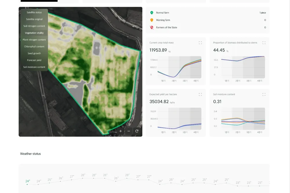
The SaeFarm platform is innovative in that it uses 12 satellites to photograph farmland worldwide on a daily basis, and AI analyzes this data to automatically calculate crop status information. The cloud-based AI deciphers the spectral data of satellite imagery to detect crop disease patterns, drought stress, and nutrient deficiencies with 98% accuracy. Algorithms for a total of 37 major crops have been pre-trained to provide insights tailored to specific regions and varieties.
Unlike existing precision agriculture solutions, it does not require any on-site sensors or drones, and can be easily used with a smartphone app anywhere with internet access. In addition, based on the collected data and past cases of over 100,000 hectares of farmland, a professional agricultural consultant AI provides farmers with"1:1 Crop Cultivation Advice"For example, it suggests action items such as "Early signs of pests detected in the north area of the paddy field – fungicide application required" or "Insufficient soil moisture in the east field – irrigation recommended within 2 days."
In particular, this service is priced at a subscription fee of around $12 per month, making it significantly more affordable than traditional precision agriculture, which costs over $2,500 per hectare. In fact, it has already been introduced to 25,866 hectares of farmland in several countries, resulting in a 98% reduction in operating costs and a 20% increase in yields, proving its effectiveness as a major differentiator.
In summary,"Satellite + AI + Low Cost"distinguishes it from competing services by providing an agricultural assistant that anyone can use.
Key Adopters
The main customers arefarmers and agricultural corporations around the world (B2C/B2B).It can be used regardless of farm size, from small to large farms, but it is especially effective for medium to large farms that have difficulty with detailed management due to labor costs.
In addition,agricultural cooperatives or government agricultural departments (B2G)can also subscribe to this platform and use it as a tool to monitor crop conditions in their jurisdiction and support farmers. For example, the agricultural department of a local government in Korea may apply for the SaeFarm service on behalf of local farmers, or the government of a developing country may use it on a national scale to predict food production.
From a B2B perspective, agricultural consulting firms or seed/fertilizer companies can also use this data to suggest better solutions to their customer farmers. In short, it is universally valuable to individual farmers (B2C), agricultural organizations (B2B), and public agricultural institutions (B2G).
Scalability
This service can target the global market and is already being used by farmers in several countries with multilingual support. Satellite data is secured globally, so there are no regional restrictions, and the AI model is gradually being expanded to suit various crops and climate zones.
In the future, the algorithm can be applied to areas other than agriculture, such asforestry (forest monitoring)or environmental management (wetland, water resource monitoring), which offers great potential for business expansion. The service itself is software-based, so there are few regulatory barriers, and it is in line with the digitalization policies of the agricultural sector, so it is likely to receive government support from various countries.
However, attention should be paid to language and unit conversions for each crop for accurate localization, and education may be necessary if farmers have low digital literacy. As the price is set very low, it is expected to generate profits through an economy of scale model that secures many subscribers, and based on the vast amount of agricultural data secured through this, the business can be expanded to include agricultural supply and demand forecasting and financial (agricultural insurance) services in the future.
Overall, it is a scalable SaaS with excellent growth potential compared to input.
Judges' Evaluation
Introduced as a winner of the Innovation Award in the Sustainability and Energy Transition category at CES 2026,it was praised for "simultaneously capturing agricultural productivity and sustainability with technology."Professional journals such as Electronics360 commented that *"It's like having an AI-based daily farm doctor for the average farmer,"* and agricultural officials paid particular attention to the low cost.
Even large farm operators who used expensive drones or sensors in the past were surprised by the accuracy and affordability of SaeFarm, and the expression"democratization of agriculture"even came out. Some pointed out the limitations of satellite data resolution, mentioning that it may be difficult for small-area crops or crops inside greenhouses, but overall, there is great expectation that it is a"technology that will contribute to food security in the face of the climate crisis."In particular, it was predicted that the introduction of this technology in international organizations and developing countries would greatly help improve food production, and accordingly, it was cited as one of the most noteworthy innovations in terms of global impact, despite being a startup.
In particular, it was predicted that the introduction of this technology in international organizations and developing countries would greatly help improve food production, and accordingly, it was cited as one of the most noteworthy innovations in terms of global impact, despite being a startup.
In a word,the unanimous evaluation is that it is a "practical innovation that has actually proven its effectiveness in the field."이라는 것이 평단의 일치된 평가입니다.
Analyst Insights
🔥 High Marketability / Business Connection Possible
The award list data is based on the official CES 2026 website, and detailed analysis content is produced by USLab.ai. For content modification requests or inquiries, please contact contact@uslab.ai. Free to use with source attribution (USLab.ai) (CC BY)
댓글 (0)
댓글을 불러오는 중...